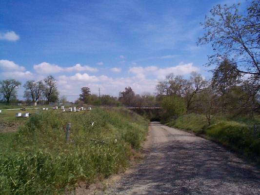
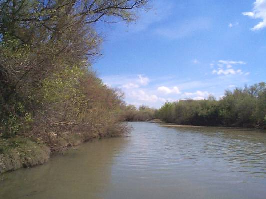
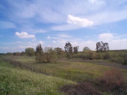
The Hike: You can do this hike in either direction, and any of the sections. I will describe it from Pedrick road to Old Davis road. Note that the south side of the creek is private property and the trail is on the north side of the property on University land. Do not go on the south side. The area of the creek open to the public is ONLY on the north side of the creek between Pedrick Road and Old Davis Road. Upstream from Pedrick Road and downstream from Old Davis Road is not open to the public or is private property. Starting at the Pedrick Road parking area, hike east along the dirt road on the north side of the creek that parallels the creek. Cross under the Pedrick road bridge, and continue downstream. When the dirt road gets to the fire ring picnic area, it will become paved. You can walk down to the fire ring area, and then back up to the paved section of road, or continue on a trail near the creek (can be underwater in winter). Continue toward the Brooks road parking area, downstream. From the Brooks Road parking, there is a trail continuing to Old Davis Road. Along the way, you will see box elder, valley oak, arroyo and sandbar willow, California grape, California wild rose, and Cottonwood. In Winter, this footpath is frequently flooded by high water. In that case, you will have to walk the levee to Old Davis road. My favorite part about this hike, in addition to the creek, is the fact that it is in Davis! A great place to get away from it all, but without having to travel the long distances. Distance: From Pedrick road to the gravel parking area at the levee, it is 1.2 miles. From the levee to Old Davis road, it is 1.5 miles. No discernible elevation change. For more information on the Putah Creek Riparian Reserve, go to putahcreek.ucdavis.edu. There is a map below, as well as one downloadable from the University at this link. |
How to get there: Depending on which trailhead you are going to, there are a number of ways to get to the parking spots. Be Aware: The south side of the creek is private property. The trail is on the north side of the creek on University property. Do not hike on the south side of the creek. Pedrick road parking: There is a gravel/wood chip parking area on the north side of Putah Creek, west of the Pedrick road bridge, on UCD property. If you are headed south from Russell blvd, turn right just before the bridge and park in the gravel/wood chip parking area. Sometimes people illegally park on the south side of the bridge next to the road but this is private property, so don't park there! Fire ring parking: Take Hopkins Road south, past the airport, until you see the creek. Park off of the side of the road, on the north side. The fire ring picnic grounds have picnic tables and a fire pit. Brooks road parking: Continue on Hopkins road past the airport, go past the fire ring parking, and continue on the paved road until it begins to curve north, and you see the beginning of the gravel levee road. Park outside of the levee gate in the gravel parking area. The trail starts at the gravel area, and parallels the creek. There are two picnic tables here as well. Old Davis Road Parking: There is a new parking area at Old Davis Road. It is on the north side of the creek, downstream from the bridge. It is a big gravel area, and the gate is always open. Park here, instead of the side of the road. It's much safer. There are two picnic tables here as well. Don't park on the south side of the bridge, since this is private property! |
| Photos | |||
 |
 |
||
 |
 |
||
 |
 |
||
 |
 |
||
 |
 |
||
 |
 |
||
 |
 |
||
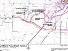
| Map (.pdf file) |
 |
| GPS track (.gpx format) |
| GPS track is not yet available. |